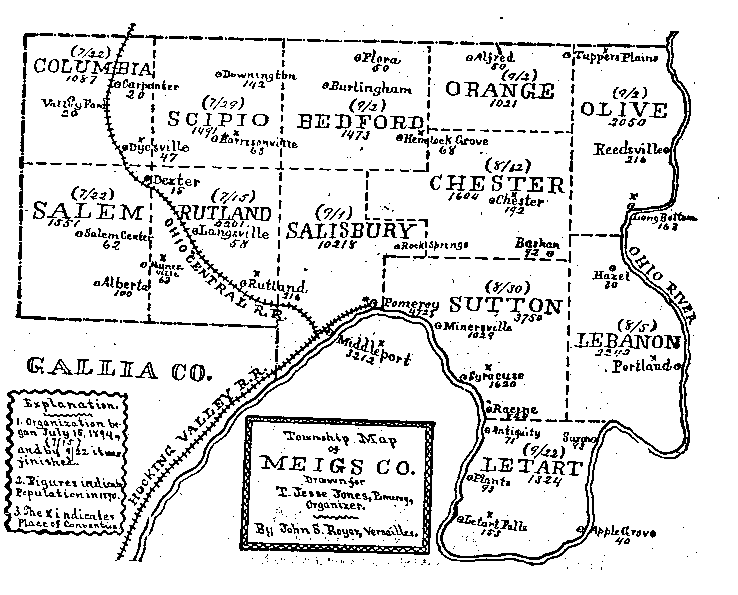
It has been said that the geography of a country often deter
mines the history of that country, and this may be true of Meigs
County.
This county is bounded by the Ohio River on the east
side entirely, on the south side for more than half of its southern
boundary, and much of its western boundary is formed by the same
stream. Its total boundary consists of less than one hundred miles,
and about sixty miles of this boundary are included in its water
front. - Pioneer History of MeigsCounty Ohio to 1949
Note: Click on map image to zoom in.
Map |
Description |
Left click to zoom or Right click on image to save map | |
![]() |
Meigs County Map - Ohio Dept. of Transportation |
![]() |
Meigs Township Map - This map was originally published in a booklet produced by the Meigs County Sunday School Association in 1895, and was provided by Joel Hartley. Thanks, Joel! |
![]() |
Map of Ohio Counties – Map source: Perry-Castaneda Library Map Collection, University of Texas - LINK |
![]() |
Middleport/Pomeroy/Racine Area Map – - cropped area of 1992 U.S. Geological Survey Topo map USGS 1:24000-scale Quadrangle for Pomeroy, OH 1992 |
![]() |
Zoomed Middleport/Pomeroy/Racine Area Map – - cropped area of 1992 U.S. Geological Survey Topo map USGS 1:24000-scale Quadrangle for Pomeroy, OH 1992 Open full Quadrangle Map for Pomeroy in new tab (16MB) - LINK |
![]() |
Meigs County Map with land owners - The Democrat (Small) - Year Published Unknown: This map courtesy of Meigs County Tax Map Office. - LINK |
![]() |
Meigs County Map with land owners - The Democrat (Full Size 18MB) - Year Published Unknown: This map courtesy of Meigs County Tax Map Office. |
Page Updated July 2025
© Copyright 1996 - Our Submitters, OHGenWeb & USGenWeb® All Rights Reserved.